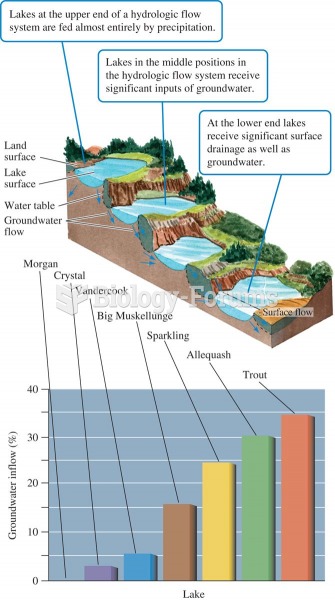
The Mansurs and the Muskopfs own adjoining lots in a subdivision located along Lake Winnipesaukee. Because of mistakes in surveys and the placement of the boundaries, there is some confusion about where the boundaries are located. The boundaries are accurate on the plat map and their deeds use the plat map as a description. However, the way the boundaries have been on the lots is different and the Mansurs have been using part of the Muskopf lot. The plat map was first recorded in 1958 and the developer conveyed the lots to the original owners who then conveyed to the Mansurs and Muskopfs. All of the owners before also used the lots the way the Mansurs and Muskopfs have. Which of the following is correct?
A)The boundaries on the lots are those in the 1958 plat map and the deeds.
B)The boundaries cannot be changed by actions of the parties when the deeds and plat map are the same.
C)The boundaries are as the Mansurs and Muskopfs are using them.
D)The boundaries cannot change from the plat map and deed descriptions because the same people have not owned the lots.

 Quick Reply