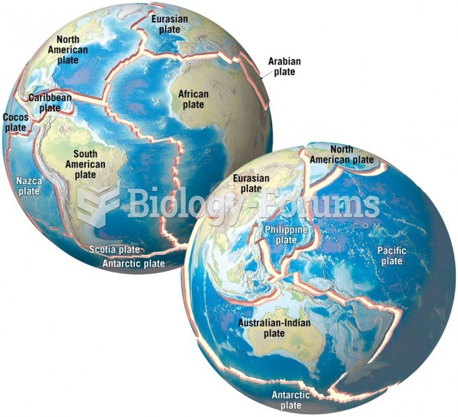
The physical environment is influenced by the ways in which human societies value and use Earth's physical features and processes. This statement best describes which of the following six essential elements of geography as outlined by the National Geographic Society?
a. The World in Spatial Terms
b. Human Systems
c. Environment and Society
d. Physical Systems
e. Place and Regions
Question 2Geography knowledge enables people to understand the relationships among people, places, and environments over time. This statement best describes which of the following six essential elements of geography as outlined by the National Geographic Society.
a. The World in Spatial Terms
b. Human Systems
c. Environment and Society
d. Physical Systems
e. Uses of Geography
Question 3The coordinate 47 39' 56'' N, 81 3' 28 E would be located in the _____.
a. Northern hemisphere mid-latitudes
b. Northern hemisphere low latitudes
c. Northern hemisphere high latitudes
d. Southern hemisphere mid-latitudes
e. Southern hemisphere low latitudes
Question 4Why is the concept of regions in geography useable?
a. All regions are countries.
b. All regions are very large.
c. It allows for an exact study of a specific area for a specific purpose.
d. It is the only way computers can be used with geographic data and follow political lines.
e. Regions are another name for the seven continents.
Question 5A system of values, beliefs, and attitudes that shape and influence behavior is called a(n) _____.
a. model
b. vernacular
c. place
d. location
e. culture
Question 6What is the collection of physical and human geographic features on Earth's surface called?
a. a model
b. a map
c. a region
d. a landscape
e. a projection
Question 7At what angular distance is the International Date Line from the Prime Meridian?
a. 0 degrees
b. 45 degrees
c. 90 degrees
d. 180 degrees
e. 360 degrees
Question 8Which type of map would a map showing the movement of Syrian refugees be classified as?
a. choropleth
b. isarithmic
c. graduated symbol
d. dot density
e. flow

 Quick Reply